 |
| Paradise Lake |
Paradise Lake is located north of Sierra Nevada's Basin Peak, which is located north of Castle Peak; all north of Boreal at Donner Summit. Day hikers typically start their Paradise Lake round trip from next to Interstate 80: either from the Pacific Crest Trail parking area (south of I-80) or from wherever they may get to on Castle Valley Road (a dirt-road trail north of I-80); for example, from the shaded parking area at the trailhead of the Hole in the Ground (HITG) Trail.
Once you have managed Castle Pass and have arrived at the Peter Grubb Hut, you want to continue northbound on the PCT until you will arrive at its junction with the Paradise Lake Trail in Paradise Valley. North of the hut you will cross Lower Castle Creek and then pass the junction with Sand Ridge Trail, a connector trail linking the PCT with the HITG Trail and Sand Ridge Lake. The PCT traverses the eastern slopes below the crest between Castle Peak and Basin Peak with spectacular views of the western Sierra, including Sierra Butte further north. There is an unmarked Y-junction, from where a trail ascends to the top of Basin Peak.

 |
| Unconformity Spring |
From there, with Mike White's words [1]:
A mild, winding ascent leads past a pond surrounded by meadow to a junction with an old road, 6.6 miles from the trailhead [PCT parking area (south of I-80)]. Nailed to a lodgepole pine just before the road is an old wooden sign marked PARADISE LK, with an arrow to the right.
 Exactly. The sign is still there. The tall lodgepole pine is getting to old age. Resin is dripping from a wound in the bark.
 |
| Resin of a lodgepole pine |
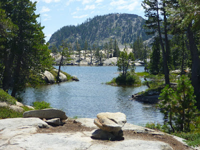
Paradise Lake is surrounded by granite slabs and cliffs. Tiny granite boulder islands seem to float in the lake, some with bonsai-like and some with surprisingly tall conifer trees. On a hot day, you may want to make a water-surrounded granite floor your resting spot, from where you can easily walk or slide into the refreshing lake water.
[1] Mike White: Afoot & Afield. Wilderness Press, Berkeley, California, 2nd printing November 2008.


No comments:
Post a Comment