Friday, December 4, 2015

Once added to the edge of North America

Mastodon sketch along Keystone Canyon Trail
The Peavine Mountain and its foothills northwest of Reno, Washoe County, Nevada, are today a popular recreation landscape, where locals and visitors come for hiking, horseback riding as well as mountain and dirt biking adventures. Since the area is mostly devoid of trees, great views of the Truckee Meadows, Red Hills, Virginia Range and Mount Rose Wilderness can be enjoyed.

Traveling Keystone Canyon Trail, you will pass a mastodon sketched on an informative panel, which explains in brief how the Peavine area and northwest Nevada was formed geologically:

About 200 million years ago, the rocks you see to the west were at the ocean floor. The North American continent was to the east. Underneath the surface, tension was mounting as the oceanic crust converged with the continental crust of the North American plate.

The ocean plate was forced down, under the western edge of the continental plate, turning the peaceful landscape into a chaotic jumble of activity. For millions of years the plates converged, scraping off oceanic rock onto the edge of the continent, and melting some of the oceanic crust that was forced deep into earth. As the shoreline extended westward, rocks that now form the Sierra Nevada Range and Peavine Mountain were beeing added to the edge of the continent.

About 20 million years ago, the region east of the Sierras began to be stretched apart, breaking up the crust into blocks. More recently, probably starting less than 5 million years ago, much of the Carson Range was uplifted.

Fossil discoveries indicate that Nevada was once home to large mammals such as elephantlike mastodons. The panel says:

2.5 million years ago the land of this region was flatter - lush and green, with plenty of lakes, and active volcanoes. It was a different world - not recognizable as the Peavine Mountain we know today. Many of the plants and animals would be strange to us - like the large furry, elephant-size MASTODONS that foraged on the lush vegetation.

About 10 years ago, the Peavine foothills were still cluttered with car wrecks. They were removed from hillsides and canyons. Corroding metal assemblies would be strange to us now. Steep, hillside-eroding dirt roads are getting replaced by switchbacking single-track trails. Non-motorized recreation activities are extending westward, building a recreational trail network from Reno to Verdi and into California all the way to the edge of the continent.  

Sunday, October 11, 2015

From the southern tip of Fallen Leaf Lake to Angora Ridge & Lakes: Angora Lake Trail

View of Fallen Leaf Lake and Lake Tahoe from upper Angora Lake Trail
Angora Lake Trail
The Angora Lake Trail connects the southern tip of Fallen Leaf Lake with the Angora Ridge between Tahoe Mountain and Angora Peak, south of Lake Tahoe in California. The steep single-track trail ascends through mixed forest. Warm up by climbing the easy-to-follow, but rocky switchbacks. Once you get closer to the ridge, the trail turns into a soft, needle-covered forest path. Take a break without missing the opportunity of  far-reaching views—framed by conifer trunks and branches—across Fallen Leaf Lake and Lake Tahoe towards the northern peaks of the Carson Range.

From the ridge, it is only a short, level hike to the parking area of the Angora Lakes Resort. Your effort to come up here from a public parking lot at Fallen Leaf Lake will save you the $7 parking fee at the resort entrance (and a bumpy ride over the rough Angora Ridge Road). The unpaved resort path leads uphill to the lower Angora Lake, with several cabins to your left. The public path continues alongside the lake. A short incline leads to the upper Angora Lake, which is semicircularly surrounded by rustic cabins, while the opposite lake side is bordered by steep slopes and cliffs.

Lower Angora Lake, early October 2015
The north side of the upper Angora Lake has a public beach, inviting visitors to wade through the shallow waters. If you brought your swimsuit, you may want to swim across the deep blue spots in the lake toward the rock walls. There are no lifeguards on duty. A notice warns about the danger of off-cliff jumping,with injuries and fatalities happening each season. Simply, enjoy the marvelous view of backdropping Echo Peak from the water or the shoreline or—during resort season—from a rented boat or the lemonade stand.  
The shallow water of the upper Angora Lake

Getting to the Angora Lake trailhead west of the Fallen Leaf Lake Marina and Store

The trailhead is located between the Fallen Leaf Chapel and the Fallen Leaf Fire Station next to Fallen Leaf Road. The writing on the trailhead sign is fading and needs some fresh paint to better contrast its background.

To get there, go south on Fallen Leaf Road from its junction with Highway 89, just west of Camp Richardson at the outskirts of South Lake Tahoe. Follow Fallen Leaf Road for about 4.5 miles. Alongside Fallen Leaf Lake, this is a narrow single-lane road through lake-side neighborhoods with turn-outs. At the lake's end, the chapel and fire station is on the left side of the road. If you don't find parking there, consider taking the paved, narrow road—uphill and alongside Glen Alpine Creek—to the public parking area at the Glen Alpine trailhead and walk back the half mile to the Angora Lake trailhead.  

Saturday, October 10, 2015

Sticky monkeyflower growing in the shrubland of Rancho Corral de Tierra

Orange bush monkeyflower
A pair of tubular flowers of Mimulus aurantiacus, growing in Rancho Corral de Tierra
Rancho Corral de Tierra is rugged, chaparral-covered land between the upper ridges of the Montara Mountain and the Pacific coast in San Mateo County, California. Easily accessible, but steep trails, including French Trail and Clipper Ridge Trail, invite hikers to explore this open space terrain south of San Francisco. From almost everywhere along the Rancho ridges, the ocean vistas are breathtaking. Endangered and endemic species such as Hickman's cinquefoil and invasive species such as pampas grass from South America occur in Rancho. Also, sticky monkeyflower (Mimulus aurantiacus) with its deep green sticky leaves grows and blooms on the dry soil of the rocky hillsides in Rancho, usually between March and September. Its long blooming season benefits nectar-thirsty hummingbirds for half the year.

Sticky monkeyflower is found throughout California and beyond, with flowers varying in color from pinkish white to brilliant red. The most common corolla color is yellow-orange. This color and the fact that plants grows up into branched shrubs explains the other name: orange bush monkeyflower.

The tubular flowers of the bush monkeyflower typically come in pairs. The picture above shows a pair of yellow-orange flowers of a plant found next to the upper Clipper Ridge Trail in mid-September. The picture also shows the opposite, lanceolate leaves with rolled-under edges.

Note: Depending on which of my field guides I am consulting, I am finding Minumuls aurantiacus, pronounced MIM-yoo-lus aw-ran-TIE-a-kus, grouped within the lopseed family (Phrymaceae) or within the snapdragon family or figworth family (Scrophulariaceae). My understanding is that Mimulus species had traditionally been placed in Scrophulariaceae, but are now classified as Phrymaceae based on DNA studies shining new light on phylogenetic relationships (see, for example, a paper by Beardsley and Olmstead in the American Journal of Botanty 2002, 89(7), pp. 1093-1102: Redefining Phrymaceae: The Placement of Mimulus, Tribe Mimuleae, and Phryma). Not enough, the scientific name has been changed from Mimulus aurantiacus to Diplacus aurantiacus: Welcome to monkeyflower science!

More about Mimulus aurantiacus:
Golden Gate National Parks Conservancy: Mimulus aurantiacus (Sticky Monkeyflower) [www.parksconservancy.org/conservation/plants-animals/native-plant-information/sticky-monkeyflower.html].
California Phenology Project: Sticky Monkeyflower (Diplacus auratiacus) [www.usanpn.org/cpp/MIAU].
Michael L. Charters: Mimulus aurantiacus Curtis [www.calflora.net/bloomingplants/bushmonkeyflower.html].

Thursday, October 8, 2015

A hiking loop in the Rancho Corral de Tierra foothills: French Trail and Clipper Ridge Trail

Clipper Ridge Trail's steep downhill path through chaparral with Princeton and the Pillar Point Peninsula at the bottom
About one mile north of Pillar Point Harbor, several trails crisscross the foothills at the southern end of Rancho Corral de Tierra. A few trails lead uphill, traversing steep slopes and long ridges. They are flanked by tangled shrubs and, in many places, by nonnative pampas grass. The views are spectacular: Montara Mountain further north, Princeton-by-the-Sea just “down the hill” and Half Moon Bay in the south. French Trail and Clipper Ridge Trail are rough dirt-road tracks through the Rancho area between Denniston Creek and Deer Creek. They make the upper Rancho terrain accessible.  

Invasive elegance of pampas grass
For a clockwise loop hike, follow the northwest-bound trail beginning at the end of Coral Reef Avenue. Pass its junction with Flat Top Trail and continue on the uphill trail you are seeing ahead of you. There are some trail markers, but until now I haven't found trail names posted at junctions or intersections. Fortunately, this is open space with an open view, supporting orientational place recognition and trail spotting.

Upper Clipper Ridge Trail
After climbing French Trail for about half a mile, you'll find a sign on your left, saying that there is no access to the “agricultural protection area.” Keep climbing. After about another mile, the French Trail meets the Clipper Ridge Trail. Before turning right and returning downhill, you may want to continue uphill for another mile to reach the level section of Clipper Ridge Trail with trees, shade and magnificent vistas. Further east, Clipper Ridge Trail bends into Deer Creek Trail, which goes downhill into Quarry Park and El Granada neighborhoods.

From the French Trail/Clipper Ridge Trail junction, you passed earlier, Clipper Ridge Trail starts its steep downhill course—shown in the top picture. After about one mile of descend, you will arrive at the junction with Flat Top Trail and Almeira Trail. Hike right on Flat Top Trail and at the next junction turn left and take the trail that takes you straight through a stand of eucalyptus trees to the starting point at Coral Reef Avenue.  


Getting there
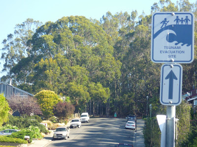
Rancho Corral de Tierra is located about ten miles south of San Francisco, California. From Highway 1 (Cabrillo Hwy), about half a mile northwest from the traffic-light intersection between Princeton and El Granada, turn right on Coral Reef Avenue. Follow this road uphill to its end, which is a tsunami evacuation site with a few parking spots.

From Cabrillo Hwy to Rancho trailheads: Coral Reef Avenue
Trailheads and tsunami evacuation site at the upper end of Coral Reef Avenue

Wednesday, October 7, 2015

Trails north of El Granada in San Mateo County, California: Rancho Corral de Tierra

About ten miles south of San Francisco, Rancho Corral de Tierra, Rancho as it is called by locals, is part of the Golden Gate National Recreation Area (GGNRA)—a U.S. National Recreation Area that protects ecologically sensitive habitats and historically significant landscapes surrounding the San Francisco Bay Area [1-4]. The Rancho park connects McNee Ranch State Park and San Pedro Valley County Park south of Pacifica with Quarry Park and El Granada north of Half Moon Bay; although, currently there is no assigned trail encouraging an inter-park, north-south (or south-north) hike through Rancho lands.

Rancho has a history of Mexican cowboys stomping its grounds and of booze-smuggling artichoke vendors finding refuge in the rugged tierra. Grandiose development plans for this scenic land were dreamed up; instead, it became public open space [1]:

Despite this history, the land itself hasn't changed much, which has set the stage for Rancho's newest incarnation as the site of the most recent addition to the Golden Gate National Recreation Area. The remaining 4,000 acres of Guerrero's parcel [since 1838 grazing land luring ranchers such as Mexican settler Francisco Guerrero y Palomares] will now help to complete one of the largest swaths of open space in San Mateo County.

Several freshwater creeks cut through the former ranch land from northeast to southwest to meet the coastline. Existing trails mostly follow the ridges between the creeks. The trails are flanked by low-growing coastal scrub. Hikers coming up the steep trails are rewarded by spectacular views of Pillar Point Harbor, the peninsula shoreline to Maverick's Beach and the beach sichel of Half Moon Bay.

Princeton and Pillar Point peninsula with harbor side shoreline seen from a Rancho Corral de Tierra foothill
The park vegetation includes nonnatives such as Harding grass and pampas grass, which park staff is trying to take out, while restoring and strengthening natives including purple needlegrass (California's state grass in 2004), blue wild rye and California oat grass. The beautiful, endemic and endangered Hickman's cinquefoil (Potentilla hickmanii)—for over fifty years believed to be gone—is still found today on Rancho soil [1]. 

The list of Rancho trails consists of Deer Creek Trail, Clipper Ridge Trail, French Trail and Flat Top Trail north of El Granada; Farmer's Daughter Trail, San Vicente Trail and Spine Trail east of Moss Beach; and Alta Vista Trail north of Montara. Locals have created a network of informal trails and paths, especially in the lower foothills.

Keywords: San Mateo peninsula, open space, native ecosystem, trail connections.

References and more to explore
[1] Victoria Schlesinger: A Sea-to-summit trek on the San Mateo Coast. Bay Nature January-March 2015, pp. 12-15.
[2] National Park Services: Rancho Corral de Tierra [www.nps.gov/goga/rcdt.htm].
[3] Peninsula Open Space Trust: Rancho Corral de Tierra [openspacetrust.org/whatwesave/rancho-corral-de-tierra.html].
[4] Rancho Corral de Tierra maps [www.nps.gov/goga/upload/map-rcdt-4color-2013-0703.pdf].

Rancho Corral de Tierra and Montara Mountain
Montara Mountain seen from Clipper Ridge Trail

Monday, October 5, 2015

Pillar Point Harbor's West Shoreline Trail to Maverick's Beach

Harbor-side shoreline of Pillar Point peninsula
The shoreline trail of the Pillar Point Harbor District connects the Pillar Point Marsh west of Princeton-By-The-Sea with Maverick's Beach. This trail allows for a pleasant stroll past harbor tide pools—with backwards views of the Montara Mountain—toward the outer harbor jetty. From there, beach walkers may want to continue westward to the rock assembly off Pillar Point near where the famous Maverick waves are rolling in after a strong winter storm.

The Pillar Point Marsh is a small, but important spot along the Pacific Flyway. Migrating birds rest and feed here. Full-time residents such as the Great Blue Heron find small fish, insects, amphibians and reptiles in the marsh, which they often spear with their long bill.

Rocks and tide pools off the shoreline trail
Between the marsh and the outer harbor jetty are tide pools and flat rocks to explore, accessible depending on the tide. At the beginning of the jetty you'll find a warning sign alerting danger due to deadly waves that may occur at any time. The jetty is considered unsafe for walking. Indeed, climbing rather than walking would be required to manage the rocks and voids of the jetty. Many times when I came by I saw people hanging out on and between the jetty boulders, apparently not afraid of slippery surfaces and waves.

Rocks between Maverick's Beach and Mavericks off Pillar Point
To enjoy the evening sun, the western end of Maverick's Beach is a nice place. This is also a great location for bird watching. Bring your binoculars to focus in on the activities of sea birds on, around and above the off-shore rocks. At high tide, Maverick's Beach becomes a narrow stripe of sand. Expect rushes of whitewater and possible debris falling from the steep cliff of the Pillar Point peninsula. To watch surfers during a Mavericks surf contest, the rock formation blocks the view of the wave-break area further out. The safest places to watch competitors in their heat is at home on an Internet webcast or in a bar or restaurant around Princeton Harbor. 

Getting to the West Shoreline Access parking lot
Get to the intersection of Highway 1 with roads leading to El Granada and Princeton. This intersection southeast of the Half Moon Bay Airport has a traffic light. Turn west on Capistrano Road. Follow this road through the Pillar Point motel & restaurant neighborhood and turn left  on Prospect Way. At the end of this short road, turn left on Broadway. After 150 ft, turn right on Princeton Avenue. At the western end of Princeton Avenue, turn right on West Point Avenue and follow this road all the way around the Pillar Point Marsh until you get to the Tide Pools Parking Lot, which are located on the left side of the road, just before the road starts ascending toward the Pillar Point Air Force Station.

Saturday, October 3, 2015

Where do Devil's Slide landslides occur?


Devil's Slide Trail is a paved hiking and bicycling trail through a coastal erosion landscape south of the Pedro Point Headlands in San Mateo County, California. Its scenery is amazing. Its ground and surroundings are unstable and slippery. Along the trail, travelers enjoy the spectacular views of the Pacific Ocean. With awe, visitors also scan the walls and slopes of crumbling and sliding sedimentary rocks.

Powerful forces are at work at Devil's Slide. The above clip from an interpretive panel along Devil's Slide Trail illustrates the slide area with its cliffs and steep slopes. The panel labels the ongoing activity as “The Big Squeeze” and describes this phenomenom in detail:

Devil's Slide sits between San Pedro Ridge, a rock ridge squeezed upward by the earth's tectonic forces, and Montara Mountain. The slide is about half a mile wide and extends 900 feet from the ridge top to the ocean. Millions of years of upward pressure has broken and weakened the rock of these cliffs. Water trapped underground causes the weakened rock to move. At the same time, the pounding surf washes away the bottom of the slide. Devil's Slide continues to move into the Pacific Ocean, part of the natural process that shapes our ever changing coastline.

Devil's Slide Trail mostly traverses areas of sedimentary rock. A short trail section at the south leads over granitic rock. The geology-focused panel asks readers to notice how different the cliffs at the south end are compared to those at the north end. It continues:

The weathered rock face to the south is the granitic rock of Montara Mountain [about miles southeast from Devil's Slide], the same rock found in the Sierra Nevada Range. In contrast, the rough layers of sedimentary rock at the north end were once ocean floor. Not quite as old as the Montara Mountain rock, these layers of shale and sandstone have been thrust up and folded, over millions of years, by forces deep within the earth.

The panel also answers the questions asked in the title of this post:

The landslides occur where the sedimentary rock has been thrust over the granitic rock, causing broken, weakened ground.


San Pedro Point and sedimentary rock slopes between Devil's Slide Trail and the ocean

Keywords: geology, tectonics, landslides, sedimentary rocks, granitic rocks, Big Squeeze, San Pedro Ridge, Montara Mountain.

Explore the Geology of Devil's Slide:
Devil's Slide (California) [en.wikipedia.org/wiki/Devil's_Slide_%28California%29].
The Rocks of Devil's Slide [ww2.kqed.org/quest/2013/03/28/the-rocks-of-devils-slide].
Devil's Slide Tunnels Project [www.dot.ca.gov/dist4/dslide/images/devils%20slide_1updated.pdf].

Friday, October 2, 2015

A short paved segment of the California Coastal Trail between Oregon and Mexico: Devil's Slide Trail

A paved path through a landscape of coastal erosion: Devil's Slide Trail
After the opening of the Tom Lantos Tunnels, also called Devil's Slide Tunnels—two road tunnels now bypasses a two-lane segment of State Route 1 between Pacifica and Montara in San Mateo County, California—the 1.3-mile-long coastal highway stretch was updated and beautified to become a paved multi-track hiking and bicycling trail with spectacular ocean overlook platforms. It is named Devil's Slide Trail due to the history of rockfalls and landslides that frequently happen along this part of the Californian coast with the San Andreas Fault meeting the Pacific Ocean a few miles further north. A Devil's Slide information panel describes this trail within California's varied and ever-changing landscapes as follows:

The 1.3-mile-long Devil's Slide Trail is built on what was once a treacherous stretch of Highway 1 and the site of frequent landslides, accidents, and closures. When the Tom Lantos Tunnels opened in 2013, the San Mateo County Parks Department began converting this segment of the old highway to this public multi-use, non-motorized trail.
The trail opened in 2014, and offers spectacular ocean views and unparalleled opportunities for viewing birds and marine mammals.
The Devil's Slide Trail is a section of the California Coastal Trail, which will extend 1,200 miles from Oregon to Mexico.


San Pedro Point seen from Devil's Slide Trail
A Devil's Slide vista device with San Pedro Point in the background
Occasional detourings may be required, since Devil's Slide continues to slide into the Pacific Ocean, and the rising ocean keeps attacking the Devil's bottom, accelerating the erosion bottom-up.
 
A bird's-eye view of birds at the Devil's bottom
While strolling or recreating along the easily accessible, well-maintained Devil's Slide Trail between the Pedro Point Headlands and the west-side slopes of San Pedro Mountain, your escape strategies during a strong earthquake are very limited. High walls and slippery slopes on one side; steep, unsafe cliffs on the other, dropping down to a beach or into the pounding ocean surf. If this would be a mine site or a construction area, hard hats would certainly be required. But the Devil's Slide coast, today, is a preserve-like open space celebrating successful restoration efforts to regrow Common Murre colonies. The natural uniqueness, refreshing sea breezes and amazing views lets one forget potential natural hazards.
North Devil's Slide trailhead

Along the trail you will find many interpreted panels informing about Devil's Slide history, the big squeeze, land protection, environmentalist Ollie Mayer, seabird colonies and much more about the local natural history.


Getting to the Devil's Slide trailheads

Devil's Slide Trail is a San Mateo County Park. There are trailheads at either end of the trail, which can be accessed before entering or after leaving a Tom Lantos Tunnel. Parking lots are limited.

The south trailhead is on the west side of Highway 1, about two miles north of the Montara State Beach parking area.

The north trailhead is to your right, after driving southbound on Highway 1 for about one mile from Pacifica. A trail that will connect the north trailhead with Pacifica is in planning.

Sunday, September 27, 2015

Beachside geology: the Kehoe cliffs

Tortured whilte dikes cutting through granitic rock
Contorted and faulted white dikes cutting through Granite of Inverness Ridge
Most people visit a beach to play and recreate. Kehoe Beach invites visitors to additionally experience cliffs-on geoscience and to explore the natural history of the San Andreas Fault Zone. Kehoe Beach is an excellent, easily accessible field-trip destination in western Marin County north of San Francisco. Doris Sloan featured the geology of the Kehoe region in a recent Bay Nature article [1].

The generalized geologic map of Point Reyes National Seashore after Clark and Brabb (Figure 9-2 in [2]) shows that the area south of the Kehoe Beach Trail consists of late-Pleistocene-to-Recent features: alluvial depositions, beaches and sand dunes; obvious to today's visitor. The units north of Kehoe Trail include Laird Sandstone from the middle Miocene and Salinian granitic rocks from the Cretaceous period; the latter forming the Inverness Ridge.

The Laird Sandstone you can see at the Kehoe trailhead is the oldest of the sedimentary rocks in the area [3]. It originated by deposition when the sea rose or the land sank between 16 to 11 million years ago. On top of it, Monterey Formation sandstone was deposited eight to six million years ago. This formation is distributed from south to north over the Point Reyes Peninsula and exhibits a strong similarity with deposits found in Monterey further south. Therefore, it is assumed that Point Reyes, riding north on the eastern edge of the Pacific plate, was located in the Monterey area up until Miocene times [4]. Layers of uplifted Monterey Formation are exposed north of where the Kehoe Beach Trail traverses a sand-dune ridge to meet the shoreline.
Monterey Formation exposure next to Kehoe Beach Trail
Walking north on Kehoe Beach, you soon will find yourself in front of Laird Sandstone cliffs. Continue north and you continue walking back in time, geologically speaking. The gray granitic rocks to the north have been uplifted relative to those of the sandstone cliffs on the south. A small landslide marks the contact zone, a vertical fault between the sandstone cliffs and the Salinian granitic formation. The latter is also called the Granite of Inverness Ridge, which is plutonic igneous rock that formed about 85 million years ago (within the Cretaceous period between 145 to 66 million years ago) deep in the crust from magma produced during long-ago plate collisions [1].

A striking feature of the lower granitics are the bold white dikes cutting through them in puzzling, strangely twisted patterns (top picture). Doris Sloan helps us to solve the puzzle, or, at least, to make sense of it in plate-tectonic terms [1]:

If Yosemite comes to mind when you think of granite, this outcrop of granitics north of the landslide may puzzle you. No high cliffs of light-colored rock; no straight white dikes—bands of lighter, younger rock—cutting through the granitic rocks for hundreds of feet. Here you see a jumble of multicolored rocks, cut by contorted and faulted white dikes. The rocks are so mixed up and fractured, so different, that you would think there is no connection to Yosemite. However, these granitic rocks once formed the southernmost end of the Sierra Nevada, about 350 miles south of their present location; they ended up on the other side of the San Andreas Fault system and got hijacked by the Pacific plate on its way north.
Vertical fault between formations


Point Reyes is a merger of different points in time and space. You can be sure that this peacefully appearing location has gone through lots of sinking, lifting and shifting—and still does. Rising sea levels and predicted earthquakes will have their future impact on this preserve.

Keywords: geology of Point Reyes, shifting ground, deposition, sedimentation, earth science, plate tectonics.

References and more to explore
[1] Doris Sloan: A Trip Through Time On the Pacific Plate. Bay Nature July-September 2015, pp. 12-16.
[2] Geology at Point Reyes National Seashore and Vicinity, California [pubs.usgs.gov/of/2005/1127/chapter9.pdf].
[3] The Laird Sandstone [www.marin.edu/~jim/ring/ptreyes/pr_tl.html].
[4] Monterey Formation [www.marin.edu/~jim/ring/ptreyes/pr_tm.html].

Kehoe Beach Trail

Kehoe Beach
Kehoe Beach Trail is a short, level, 0.6-mile-long path connecting the Kehoe trailhead on Pierce Point Road with the sandy beaches and dramatic cliffs of the northern section of Point Reyes National Seashore, a California coast preserve. The trail and beach is named after the nearby Kehoe Ranch. The hiking trail follows a broad and low valley with views of grassy hills, coastal scrub and sandstone rocks. Not very far from the trailhead, you will approach patches of marshland. A freshwater creek is coming into view. Depending on the seasonal weather and tide conditions, the creek ends at Kehoe Beach, as in the picture above, or may be mixed with saltwater during a storm. The sand dunes next to the creek are part of a sensitive wildlife area, in which western snowy plovers nest and hatch between March and September.

Freshwater creek parallel to Kehoe Beach Trail
As the trail approaches the beach and the sound of the surf becomes louder, you will get to a bench in the sand. The beach and ocean is only a few steps away. The loose-sand trail traverses a low sand-dune ridge with a right-side exposure of Monterey Formation sandstone. You'll find more interesting outcrops, formations and crumbling cliffs while strolling north to where the beach terminates into a rock-strewn, pounding-surf zone after about half a mile. When the fog does not blow in, you may be able to locate—across a fifteen-mile-stretch of sand beaches with treacherous surf—the rock peninsula with the Point Reyes Light in the distant south.

Getting to Kehoe Beach Trailhead
Head north from the Bear Valley Visitor Center. After 0.2 miles turn left and go north on Bear Valley Road towards Inverness. Continue northbound alongside Tomales Bay on Sir Francis Drake Boulevard. After one mile from Inverness the road bends left, ascending Inverness Ridge. At the junction in the mountains, take right-side Pierce Point Road, leading north and around Tomales Bay State Park to the junction with the road to Hearts Desire Beach. Continue on Pierce Point Road, pass a couple of historic farms and also pass the Abbotts Lagoon Trailhead. Kehoe Beach Trailhead is coming up on your left about two miles north of the latter. Kehoe Beach Trail is open to pets-on-leash walking and bicycling—mud and sand bicycling it is over some sections of the mostly single-track trail.

More to explore:
[1] San Francisco Bay Area Hiker: Kehoe Beach, Point Reyes National Seashore, National Park Service, Marin County [www.bahiker.com/northbayhikes/kehoe.html].
[2] Nature Dogs: Kehoe Beach, Point Reyes National Seashore [www.naturedogs.com/hike.php?id=286].
[3] Geology at Point Reyes National Seashore and Vicinity, California [pubs.usgs.gov/of/2005/1127/chapter9.pdf].

Saturday, September 26, 2015

A short trail to learn about the long history of the Coast Miwok people: the Kule Loklo Trail near Olema

Kule Loklo Trail near the Bear Valley Visitor Center
The 0.3-mile-long Kule Loklo Trail west of Olema leads from the Bear Valley Visitor Center to a rebuilt Coast Miwok Indian Village—maintained entirely by volunteers—in what is now the Point Reyes National Seashore, a park preserve in Marin Country north of San Francisco, California. Kule Loklo means Bear Valley in the Coast Miwok language, which is no longer spoken. But the culture and spirit of the People of the Coast is still alive and of interest to everyone looking for a balanced life style within natural richness and restraint.

The trail begins by underpassing some low-leaning trees. It continues between a left-side meadow and trees to its right. An interpreted panel along the trail informs:

Kule Loklo acorn granary
The abundance of plant life in the nearby forests nourished the Coast Miwok for generations. Each plant offered a wealth of uses. Oak trees dropped their bounty of acorns in the fall and were an important food source as the earth rested during the winter. Tule grass from surrounding marshes was woven into mats or bundled together for canoes or kotcas (houses).

Today, this is not an area to experience typical California oak woodland anymore. Before arriving at the village, you will walk in front and then pass through a stand of tall eucalyptus trees (blue gum trees)—native to Australia, but alien to pre-Columbian Native Americans. In the village at the trail end, there is a reconstructed granary, illustrating how the Coast Miwok stored acorns (umpa), gathered in fall, for future use and protected from insect pests and other animals. During spring and summer months, they relocated from their inland villages to the estuaries and the coast to catch salmon and to gather seaweed, clams, abalone and other seafood during low tides. Beads and ceremonial regalia, which they made from shells, are still found in the area.

Kotcas at Kule Loklo
The reconstructed village further consists of shelters and gathering places. There are several conical-shaped kotcas (also spelled kotchas) you or your kids may want to check out by stepping or crawling into. Coast Miwok families of five or more individuals are said to have lived in one such structure. These living structures, according to another panel, were either made of tule grass or redwood bark. While the tule homes lasted for a couple of years, the redwood bark buildings lasted longer. 

Getting to the Kule Loklo trailhead

From Stinson Beach, drive north on Highway 1. At the northern tip of the Bolinas Lagoon, Highway 1 continues in northwest direction through Olema Valley between the Bolinas Ridge and Point Reyes mountain ranges. Just north of Olema, turn left on Bear Valley Road. After about one mile, turn left at the signed junction to get to the Park Headquarters and the visitor center. The Kule Loklo trailhead is to your right, next to the first parking lots you are getting to. 

From Point Reyes Station, drive south on Highway 1. After overpassing a creek, turn right towards Sir Francis Drake Boulevard. After about one mile turn left on Bear Valley Road. Go southbound for about three miles to get to the Park Headquarters junction.

References and more to explore
[1] California Indians: Miwok, Coast & Lake [factcards.califa.org/cai/miwokcoastandlake.html].
[2] John Littleton: Tracing Forgotton Footsteps. MAPOM Blog, July 13, 2015 [blog.mapom.org/category/coast_miwok]

Monday, September 14, 2015

Sandy Meadow Trail in the Sierra Nevada

Fluted volcanic cliff east of Wheeler Lake, Sierra Nevada
Fluted volcanic cliff structures south of Sandy Meadow Trail

The Sandy Meadow Trail is located north of Highway 4 between Ebbetts Pass and the Calaveras Big Trees State Park, Sierra Nevada, California. Despite its name, this single-path hiking and horseback riding trail winds through coniferous forest; only short sections traverse meadows. The trail connects the corrals on Highway 4 with Wheeler Lake further west.

Forest-framed sandy meadow
From its trailhead at Highway 4, Sandy Meadow Trail ascends northbound and soon enters the Mokelumne Wilderness. At the Stanislaus National Forest sign the trail bends west and stays fairly level for about 1.5 miles. Without challenges you should reach the first sandy meadow. The trail crosses Sandy Meadow Creek and then enters forest again. Some rock outcrops next to the trail offer nice views of the Sierra including the mountains surrounding the Blue Lakes area further north.

The trail continues westwards, up and down through forest; boulder-strewn in places. My favorite rock along the trail is a granite pyramid pointing skyward in an opening of the at intervals dense pine and fir forest. 

A natural pyramid, I assume
Frequently, you will encounter fallen trees. The trail is cleared of some trees and occasionally a path has been cut through a trunk. Other trunks you have to climb over or find your way around. At several locations, the trail crosses a creek or a meadow. It can be difficult to recognize the path in areas, where the trail leads over the sandy soil of a meadow or traverses wet and boggy patches. You want to memorize the location of the trail point at the forest opening to avoid track searching on your return trip. Sandy Meadow Trail is marked with little discs showing a silver-white backpacker with a hiking stick on blue ground (see picture above). These markers are fixed to trees. They guide hikers in both directions of the trail, but are too small to be seen across larger forest openings.

Hiking towards the upper end of Jackson Canyon, you are going to traverse meadows with stunning views to the south. My topographic hiking map—the National Geographic “Carson-Iceberg, Emigrant and Mokelumne Wilderness Areas” trail map—shows the location names Cliff Meadow and Avalanche Meadow. From east to west, the south is “blocked” by a steep, continuous cliff wall: a slightly curved cirque of fluted volcanic cliffs, a fraction of which is shown above. Darkening clouds moving over the cliffs from the southwest may easily cause a haunted feel in a psychically sensitive visitor. The cliffs show overhangs and caves. I am sure bird watchers will get their thrill exploring the avian life of these cliffs. Up to now, I didn't succeed in resourcing any ornithological information concerning this amazing cliff structure. It looks like a paradise for eagles and vultures. North-facing however, the livelihood of this vertical otherworld may be limited by enduring snow and ice curtains after a long, precipitation-rich winter season.

Chances are you or your party will be on their own in this cliff backyard, since Sandy Meadow Trail is not as frequently traveled as many other trails in the Sierra.

Getting to the Sandy Meadow Trailhead

From Minden, Nevada, take Highway 88 south to Woodfords. Turn left on Highway 89 to Markleeville. Continue alongside the East Fork Carson River and manage all the switchbacks uphill and over the Pacific Crest. From Ebbetts Pass, continue westbound past the Hermit Valley Historical Landmark. Find the Sandy Meadow Trailhead sign on the left side of the narrow road, just a short distance west from the Mosquito Lakes.  

From Arnold, California, go eastbound on Highway 4 past Calaveras Big Trees State Park and Lake Alpine. Find the Sandy Meadow Trailhead sign on the right side of the narrow road, about three miles east from the Wood Chuck Basin Trailhead.  

Friday, September 4, 2015

From Carson Pass via PCT to upper Forestdale Creek and Blue Lakes

PCT vistas: Forestdale Creek pond with Elephants Back
Forestdale Creek pond with Elephants Back's south side
The hiking distance along the Pacific Crest Trail (PCT) across the Mokelumne Wilderness between Carson_Pass and Ebbetts Pass is about twenty five miles; one way. For non-backpackers, an out-and-back trip to Blue Lake viewpoints is a great day-hike option. This trip rewards hikers with scenic views of the ancient Elephants Back lava dome and various shallow ponds within an subalpine landscape east of the Sierran crest.
Pacific Crest Trail south of Carson Pass
PCT traversing slopes east of Elephants Back
The trip begins at the Carson_Pass_Information_Center by following the Tahoe to Yosemite Trail (TYT) and the PCT with ascending switchbacks southbound through dense forest that is thinning while approaching shallow Frog Lake. In a short distance from the junction with the short side-path to Frog Lake you will arrive at the next junction where the TYT continues on toward Winnemucca Lake, Round Top Lake and Fourth of July Lake and where the PCT veers left and south around the steep east side of Elephants Back. Soon, the mountains west of Markleeville and ranges of the Carson-Iceberg Wilderness are coming into view.

Forestdale Creek and Forestdale Divide Road
From the crest next to Elephants Back, the PCT steeply drops into the basin of Forestdale Creek. The PCT crosses at least three tributary streams of Forestdale Creek—interspersed with rock outcrops—before winding uphill towards a beautiful, lightly forested area with meadows and ponds, backdropped by granite walls and talus slopes. The top picture shows one of the Forestdale ponds and the southeast-facing walls of Elephants Back. After about five miles from Carson Pass, you will reach a trail crossing. A few steps to the left is an unmarked trailhead on Forestdale Divide Road. To the right, a trail leads down into Summit City Canyon.

The trail marker at the crossing gives a distance of eighteen miles to Ebbetts Pass. Continuing southbound toward that direction, the PCT soon intersects Forest Divide Road, from where it traverses open slopes with sweeping canyon views. Then, the PCT enters the conifer forest northeast of the Upper Blue Lake. After about a mile, the lake is shining through the forest trees.  

Upper and Lower Blue Lake


Friday, July 31, 2015

PCT sideways: Paradise Lake

Paradise Lake north of Donner Summit
Paradise Lake
Backpackers hiking the Pacific Crest Trail (PCT) often look out for little extras and diversions. The scenery of Paradise Lake offers such a side adventure. It is a great place for camping and swimming.

Paradise Lake is located north of Sierra Nevada's Basin Peak, which is located north of Castle Peak; all north of Boreal at Donner Summit. Day hikers typically start their Paradise Lake round trip from next to Interstate 80: either from the Pacific Crest Trail parking area (south of I-80) or from wherever they may get to on Castle Valley Road (a dirt-road trail north of I-80); for example, from the shaded parking area at the trailhead of the Hole in the Ground (HITG) Trail.

Once you have managed Castle Pass and have arrived at the Peter Grubb Hut, you want to continue northbound on the PCT until you will arrive at its junction with the Paradise Lake Trail in Paradise Valley. North of the hut you will cross Lower Castle Creek and then pass the junction with Sand Ridge Trail, a connector trail linking the PCT with the HITG Trail and Sand Ridge Lake. The PCT traverses the eastern slopes below the crest between Castle Peak and Basin Peak with spectacular views of the western Sierra, including Sierra Butte further north.  There is an unmarked Y-junction, from where a trail ascends to the top of Basin Peak.

Unconformity Spring
After getting over the openly forested crest of Basin Peak's shoulder, Paradise Valley is coming into view. The descend into the valley takes you into thicker forest. In spring and summer, Unconfirmity Spring next to the trail is edged with a lush display of greens and wildflowers. Switchback after switchback, the PCT will lead you down to the valley floor, where a bridge (built in 1994) is crossing North Creek, the westward flowing water coming down from Paradise Lake.

From there, with Mike White's words [1]:

A mild, winding ascent leads past a pond surrounded by meadow to a junction with an old road, 6.6 miles from the trailhead [PCT parking area (south of I-80)]. Nailed to a lodgepole pine just before the road is an old wooden sign marked PARADISE LK, with an arrow to the right.

Exactly. The sign is still there. The tall lodgepole pine is getting to old age. Resin is dripping from a wound in the bark.

Resin of a lodgepole pine
Turning right at the junction and following the double-track trail between forest and meadowland, you will enjoy the views of the interestingly structured, northfacing walls of Basin Peak. As soon as the tracks of Paradise Trail get lost between trees, shrubs and granite boulders, you will know you are almost there. Just keep ascending eastbound over gravel and bedrock until you see the lake—beautifully tucked into a granite cirque basin.

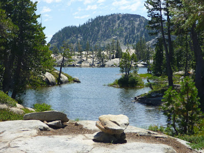
Paradise Lake is surrounded by granite slabs and cliffs. Tiny granite boulder islands seem to float in the lake, some with bonsai-like and some with surprisingly tall conifer trees. On a hot day, you may want to make a water-surrounded granite floor your resting spot, from where you can easily walk or slide into the refreshing lake water. 

[1] Mike White: Afoot & Afield. Wilderness Press, Berkeley, California, 2nd printing November 2008.