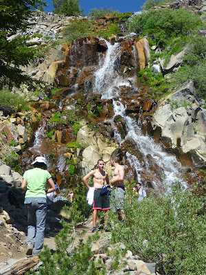
A seasonal waterfall at the northeast side of Tamarack Peak (elevation 9,897 feet) between Slide Mountain and the Mt. Rose Wilderness is contributing headwater to Galena Creek. The waterfall is found along the Mt. Rose Trail. The section of the Mt. Rose Trail between this waterfall and the “Mt. Rose Summit” Trailhead along Mt. Rose Highway (State Route 431) is also part of the new Tahoe Rim Trail (TRT). Originally, the TRT was skirting the south side of Tamarack Peak—as a gravel road between the Tahoe Meadows Trailhead and Frog Pond.
 On warm, sunny days the scenic and refreshing waterfall is turning into a gathering point and shower hub. For some hikers, it's their destination. For others, it's the actual starting point of (or returning point from) more elaborate hiking and climbing. The trail signpost there lists some destinations with hiking distances: 2.5 miles to the top of Mt. Rose, 3.5 miles to Relay Peak, 18.5 miles to the Thomas Creek Trailhead north of the Jones Whites Loop Trail and also 18.5 miles to the Brockway Summit Trailhead (see Martis Peak Fire Lookout), which is 18.5 trail miles away, located along Highway 267 between Truckee and Lake Tahoe's Kings Beach State Park.
Keywords: hiking, outdoors, waterfall, nature hub, Nevada.


No comments:
Post a Comment